Using drones to manage cattle has piqued the interest of many ranchers over the past years as their appearance in the media and in the malls becomes more common. This has led some in the agricultural community to wonder if these toys could inject a little practical application (and fun) into their cattle operations.
This notion was reinforced to Gentec in the lead-up to and post-mortem of our recent Forage to Beef Demonstration events hosted with the Foothills Forage and Grazing Association in Southern Alberta July 10th & 11th. When canvassing producers for a (non-genomic) topic of special interest to include, drone use by far generated the most interest. As confirmation, Dr. John Church’s presentation, Use of Unmanned Aerial Vehicles (UAV) to Monitor Cattle, garnered many accolades for highlight-of-the-day.
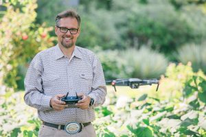
John was raised with a cattle background and went on to develop a passion for drones that he combines with his day-job as Associate Professor and the BC Regional Innovation Chair in Cattle Industry Sustainability at Thompson Rivers University in Kamloops BC. In his presentation, he touched on many of the applications below. At Gentec, we did a little digging to see what else we could uncover with respect to drones as they relate to livestock agriculture.
Advances in drone technology, and in particular, the move to multi-rotor design have greatly increased the ease with which the general public, as hobbyists and within a work environment, can control and manoeuvre these aerial vehicles. Improvements in battery life and payload capacity, coupled with inversely-proportionate reductions in price, have caught ranchers’ attention as to how they might use these toys… uhm, “tools” profitably.
Currently, for less than $2,500, you can buy a drone that has a flight time of up to 30 minutes (depending on wind and temperature), speed of 70 kph, range of 8 km—and the ability to record and transmit HD-quality video. With a little imagination and a modification or two, anybody in the cattle industry can now improve and manage their pastures, cattle herd and operational profitability.
The most straightforward application would be monitoring cattle without having to slog through pasture, bush, wind and snow to find them. From a hilltop or roadside, the rancher can make the drone do that miserable job instead. Armed with an infrared camera, the drone can spot animals day or night, and read ear-tags from a height of over 70 m, either visually with an optical zoom or potentially via RFID transmission.
Digital video and expanded sensor technologies are also opening the door to precision pasture and animal management. Infrared technology can “see” below the canopy to find animals in the underbrush. It also provides the potential to take an animal’s “temperature” and remotely identify sick or distressed animals. As a result, it relieves valuable staff time and sends people-power to where it is most urgently needed (precisely “pinned” GPS coordinates).
Similar technologies provide pasture mapping by flying grid-formations over pasture lands that, when combined with computer applications, stitch together topographical maps outlining water / moisture availability, forage and biomass availability and help optimize pasture health, management and rotation. These tools are also increasingly being applied in the ranching and feedlot setting, such as checking on troughs (remote 3D monitoring can check feed depth) and fence integrity; verifying animal inventories in paddock and on pasture; moving livestock, and searching for missing animals.
In fact, the time may not be too far off when ranchers will be able to find and herd cattle using a combination of drone and RFID technology; the drone will be programmed to fly a given route to find an individual animal or conduct a head-count within a defined area; monitor water, salt, and mineral visitation; and provide a status and / or variance report to the rancher.
Taken together, these abilities all aim to make life easier by increasing the timeliness, accuracy, cost effectiveness and convenience of gathering and processing information, and reducing the manpower that is often hard/impossible to find/afford in rural communities.
We finish with a couple of practical tips from the wise:
• Nav Canada regulations apply to the use of drones near populated areas, highways and commercial flight paths, including line-of-sight operational restrictions. Know the law.
• Hone your skills on an inexpensive model. From what we hear… the Force is strong… but there is a learning curve :)!